
Wed. August 1
Daily miles: 17.5
Cumulative miles: 17.5
Our hostel doubles as a bakery so we grab a couple of coffees and pastries before heading out. The valley is misty as we drive back to the Two Medicine entrance. Nice cool weather. Perfect for starting a long trip! I’m bound for Oldman Lake, but because the campground there is unavailable tonight, I’ll have to push on to Upper Nyack—a much longer first day than I would have chosen.
I ask the ranger at the entrance to point me in the direction of the trailhead. My maps show that it should be just short of the park entrance on the north side of the road but I don’t see any signage. I say goodbye to Isabel and Otília, who nearly breaks my heart as she bursts into tears and sobs “Papa, I love you so much.” Eventually I manage to extract her from my arms and watch the car as it heads back to East Glacier and the four-hour trip home.

Saying goodbye.
After walking at least half a mile down the road looking for the trailhead, I decide that I must have missed it and return to the entrance more than a little irritated. This is a national park! Why wouldn’t the sign be more obvious? As the entrance comes back into view, the ranger spots me and frantically points toward the woods. Okay, now I see the trailhead sign, almost entirely obscured by tall overgrowth. I had walked right past it. Not an auspicious way to begin this trip, but at least I’m finally off.
The trail ascends slowly through the forest and eventually intersects with the Continental Divide Trail. I’m unlikely to see yesterday’s thru-hikers again though. They would be starting much further south. Still, I pass a steady number of people on the trail: an overweight but enthusiastic Dad with a couple of dour teenagers, a gay couple, a solo elderly woman outfitted with very new (and very expensive) equipment. With my Panama hat and Garmin inReach Explorer clipped to my left shoulder strap, more than one person mistakes for for a ranger.
A group of German tourists below Red Mountain are clustered around a man aiming his camera at the North slope.
“A bear,” they announce as I approach. “And two cubs.”
I stop and look but don’t see anything. Even in the grainy photograph I took, it’s difficult to tell if it’s even a bear—let alone a mother on an outing with her cubs. Still, a possible bear sighting within the first few miles of my trip was encouraging. Maybe I would get to see a Grizzly after all.
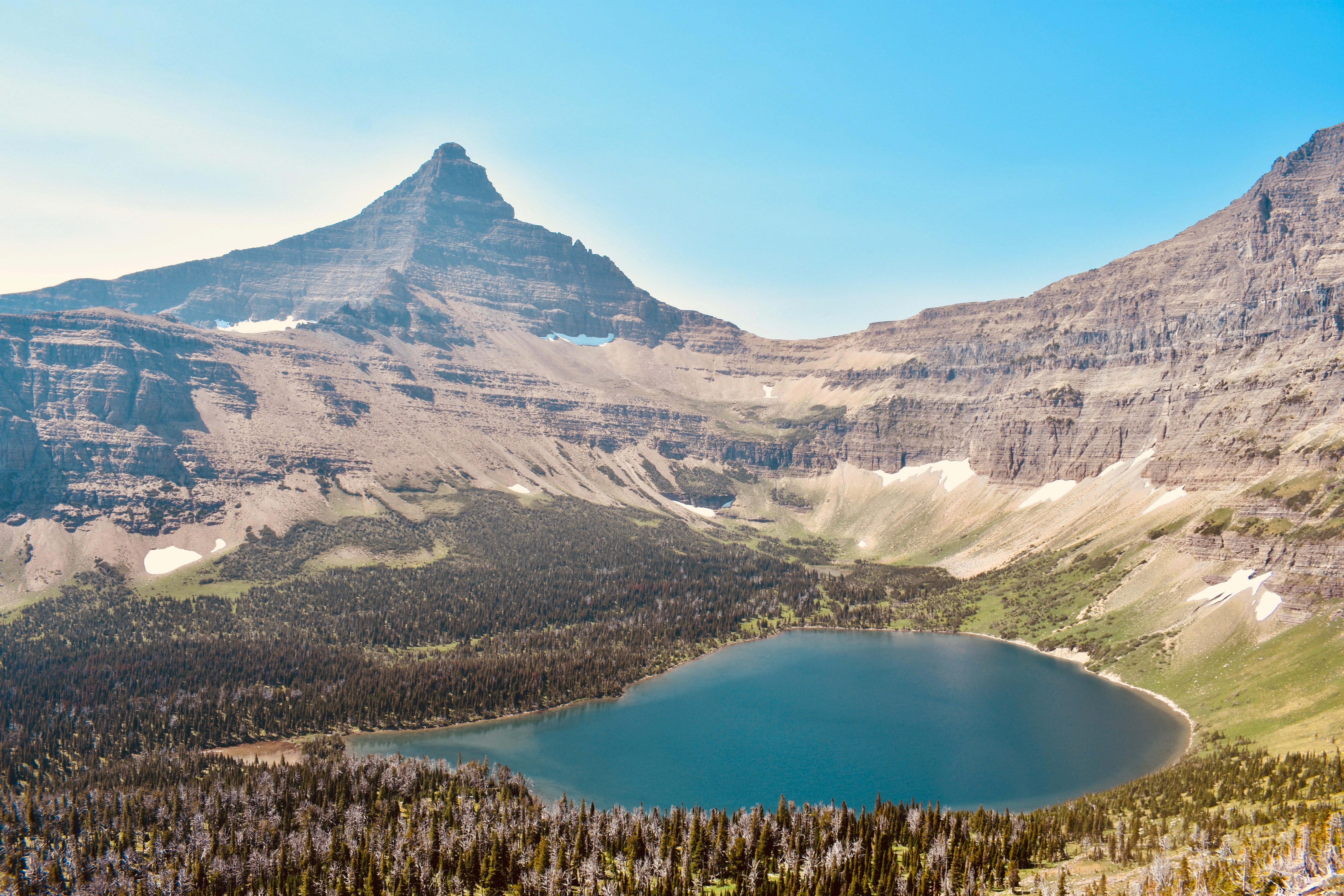
Flinsch Peak above Oldman Lake
I take the spur trail to Oldman Lake, intent on refilling my water. Clouds of mosquitos herald my arrival at the shore. A group of college women throw down their packs and fumble for their bug spray.
The views at Oldman Lake are impressive with Flinsch Peak towering above, but I can’t linger so I begin to treat my water with the Steripen. It had worked at home but now it doesn’t respond when I press the button. Hmmm, very strange. Looks like I’ll be risking untreated water on this trip. I fill up and head back to the trail up to Pitamakan Pass.
This section is very steep and I pass the moody teenagers again.
“Hey, how did we get in front of you?” Dad asks in a goofy voice. “Ah, you must have down to the lake. Really buggy, right?”
“That’s right,” I say without stopping.
The ascent from Oldman Lake up to Pitamakan Pass is the first real challenge of the day, but I take it slow, stopping periodically to enjoy the panoramic views above Oldman Lake. The other side is even more impressive from the top. It’s a beautiful clear day and I can see for miles north out to Morning Star Lake and beyond—my destination a few days from now.

Looking down at Pitamakan Lake from Pitamakan Pass
Pitamakan Pass is abuzz with activity. I smile at two men leading a group of young boys down the side of Mt. Morgan and observe at least seven people ambling along the switchbacks below me toward Seven Winds of the Lake and Pitamakan Lake. At a fork in the trail, I veer right to Cut Bank Pass and contour around McClintock Peak before beginning the long descent into the Coal Creak area via the Pitamakan Pass trail.
On the other side of Cut Bank Pass, it is suddenly silent. No one is heading in this direction. Just the wind and the warmth of the sun on my back amidst the magnificent detritus of geological spacetime. But I still have miles to go and the descent is extremely steep in this section. To make matters worse, the trail disappears entirely on the way down to Nyack Creek and it takes some basic route-finding skills to navigate successfully. A forest fire has made the task a bit easier by helpfully clearing out a great deal of the growth along the rockier stretches, but I still have to retrace my footsteps several times. It will not be fun coming back up in a few days.

Tinkham Mountain from Cut Bank Pass
The Nyack/Coal Creek area is located in the park’s southwestern extremity and I didn’t know this before I left, but it contains the only trails in the park that are not actively maintained. The area is left “as is,” which explains some of the craziness it contains for the few who venture out here. I had assumed that navigation wouldn’t be a problem in a national park. Instead, I found myself painstakingly scrutinizing subtle shifts in the pattern of plant growth to determine where exactly the trail went—and to make sure I did not wander too far from it if I took a false path.
The Pitamakan Pass Trail terminates at the Nyack/Coal Creek Loop at which point I head north along Nyack Creek to my destination for the day: Upper Nyack Campground. It’s already late afternoon by the time I arrive. The temperature is sweltering and my shins are rubbed raw from bushwhacking through endless overgrowth.
No one else is around yet, so I pitch my tent in a site closest to the creek and take a quick dip. As expected, the water is bracingly cold, but it feels good after a long first day. I rinse out my clothes and allow them to dry on me as I prepare dinner, a new concoction of mine: dehydrated cheesy tuna with brown rice and veggies. I had forgotten how good food tastes on the trail.

Hand-drawn map at Upper Nyack Creek
An older couple and their son about my age stroll into camp and we exchange pleasantries as they unload their gear and hang their food. After the initial encounter, they don’t seem very interested in chatting with me, so I make a cup of tea and leaf through a copy of Harper’s magazine—a story about climate change driving ever more frequent and intense wildfires in Montana. The state rarely makes the national media and when it does it’s usually bad.
Unfortunately, there are large ants everywhere and I’m plucking them off in the dozens as I read. The tent is no more comfortable in the full glare of the sun at this time of day, but I strip and try to withstand the heat.
The temperature plummets with setting sun and I surrender to the somnambulant drone of Nyack Creek. A good introduction to Glacier. Ⓐ
